Cradle Mountain, Freycinet and Port Arthur
After visiting Strahan and Franklin-Gordon Wild Rivers National Park on the west coast, we travelled east: Visiting Cradle Mountain, Swansea, Freycinet National Park, and Port Arthur for three days in October 2013.
It was 420 km to Swansea on the east coast via Cradle Mountain. However, we left Strahan much later than planned because I had to wait for the petrol station to open.
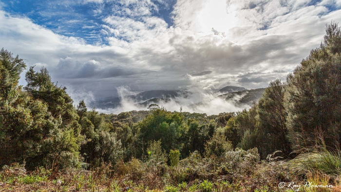
Early Morning Mist
Weather-wise it was a great start to the day with blue skies, albeit with some clouds. I stopped to photograph the early morning mist over the forest in Tasmania’s west coast wilderness. Our planned route was the B27/A10 through Roseberry and Tullah, then C132 to Cradle Mountain. I had made satisfactory progress through the valleys to Tullah. But as soon as we started to climb higher, the weather closed in, and it was snowing. The snow-covered road to Cradle Mountain Visitor Centre was just passable. The car I hired was a Nissan Tiida. It did not hold the road well, seemed top-heavy, and was hard to drive in the snow.
Cradle Mountain
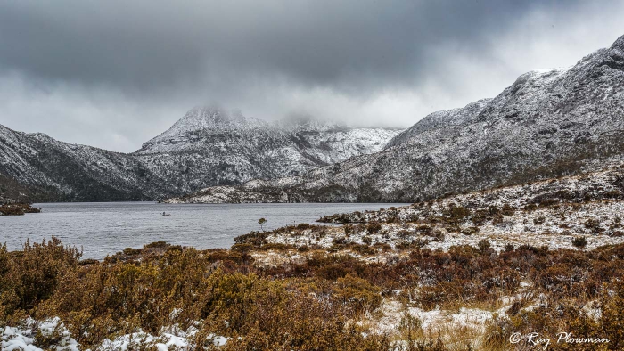
Dove Lake at Cradle Mountain
Dove Lake is at an elevation of 600m, and Cradle Mountain is at 1,545m; clouds partially obscured the mountain.
[foogallery id=”18112″]
We had arrived a couple of hours later than planned, and conditions were not favourable for walking around the lake. So, we restricted ourselves to photography around the carpark areas: Dove Lake and Ronny Creek.
There are twelve Tasmanian endemic birds, two feature in the gallery: Black Currawong (Strepera fuliginosa) and Tasmanian Native-hen (Tribonyx mortierii), the nominate subspecies.
After lunch, we continued towards Swansea on the east coast. While driving down Cradle Mountain Road, my ace wildlife spotter saw a wombat (Vombatus ursinus) grazing on scrubland. It was near Weaning Paddock Creek, a superb wildlife photography opportunity.
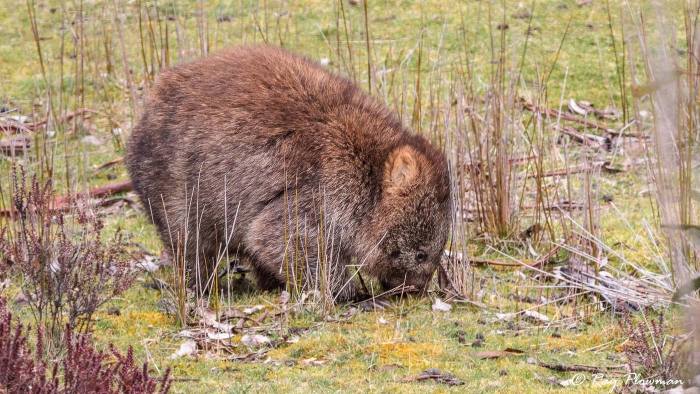
Wombat Grazing
Wombat (Vombatus ursinus) was grazing on scrubland at Weaning Paddock Creek, Cradle Mountain Road. In Tasmania, the coarse-haired, bare-nosed or common wombat is ssp tasmaniensis, while the nominate species populates the mainland.
Freycinet National Park and Swansea
Accommodation and restaurant options in the National Park area seemed limited and expensive. So, we opted to stay for a couple of nights in Swansea, a one-hour drive to the park entrance. Roads from the park entrance go 7 km west to Cape Tourville and 4 Km south to the Freycinet community. A one-day visit gave just enough time for several scenic drives, leisurely walks, and the Wineglass Bay Lookout strenuous walk.
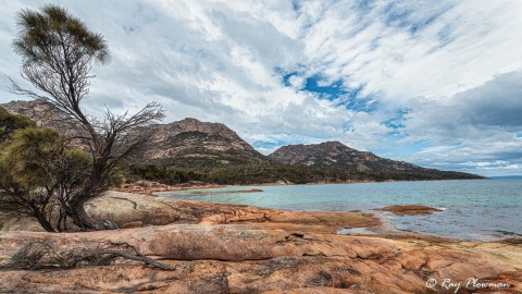
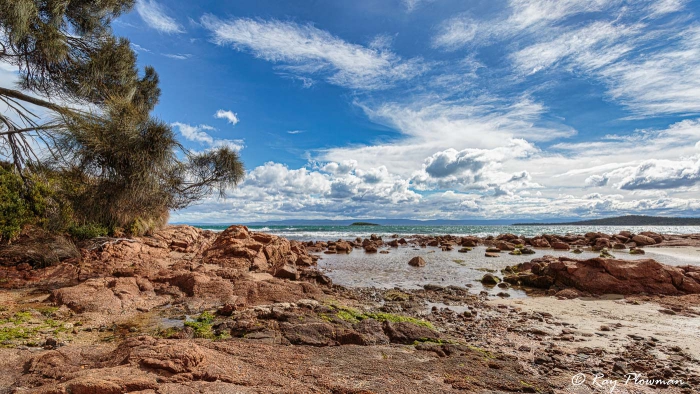
Freycinet has attractive geology, mainly rugged Devonian Granite with Orthoclase a pink feldspar, giving the coastline a characteristic pink tint. A mix of mountains, forests, heathland and flora. Great for nature and landscape photography.
Cape Tourville
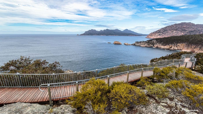
Boardwalk at Cape Tourville
The photo above shows the boardwalk at Cape Tourville and a view across Carp Bay in Freycinet National Park.
[foogallery id=”18121″]
After entering the park and we first checked in at the Visitor Centre. Then we went to Cape Tourville for an easy 600m circular walk along a compacted gravel path and boardwalk. Magnificent coastal panoramas but with an uninspiring modern automated lighthouse constructed in 1971.
Sleepy Bay and Little Gravelly Beach
Next, we backtracked along the Cape Tourville Road to Sleepy Bay carpark.
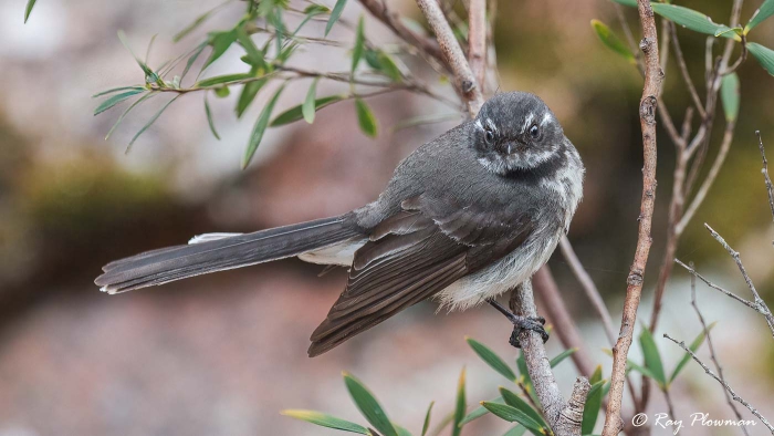
Grey Fantail (Rhipidura albiscapa)
While walking, a grey fantail followed me and posed for the camera.
[foogallery id=”18126″]
It is a short walk to the cliff edge from the car park. Then, we walked to Little Gravel Beach along the track that hugs the coast. The path is rough in places with some steep sections – it is an excellent walk with many photo opportunities. Pink feldspar coloured granite boulders dominate the beach, and some on the cliff have eroded to form shallow caves.
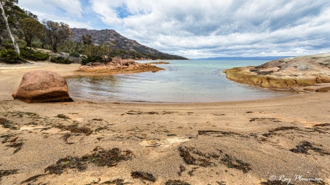
Honeymoon Bay
After visiting Sleepy Bay and having a picnic lunch, we backtracked down Cape Tourville Road to Honeymoon Bay.
Wineglass Bay Track
From Honeymoon Bay, we drove to the Freycinet community carpark for a 2.6km scenic walk to the lookouts.
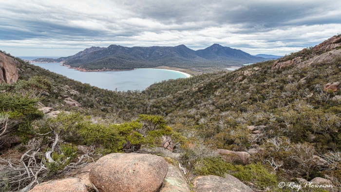
Wineglass Bay from the Lookout
[foogallery id=”18131″]
Around the Freycinet community carpark, several wallabies were looking for food scraps from visitors. One notice stated: “Feeding wallabies with scraps of food can cause a ‘lumpy jaw’ disease leading to a slow and painful death.” Since the wallabies were very tame, visitors were probably ignoring the notice.
Bennetts Wallaby (Macropus rufogriseus) is the nominate subspecies; in contrast, the mainland subspecies is the Red-necked Wallaby (Macropus rufogriseus banksianus).
Wineglass Bay Track is a part circular two-hour return walk with steep climbs. There are two coastal panoramas, walking anticlockwise; the first we encountered was Coles Bay Lookout. And the second on a spur path was the spectacular view of Wineglass Bay.
We continued anticlockwise on the circular path towards the carpark from Wineglass Bay lookout. I stopped to photograph the flowers of several southeast Australian endemic native plant species on the way back. The gallery below displays a selection.
Native Plants at Wineglass Bay Track
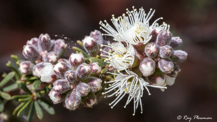
Tick Bush or White Kunzea
At Wineglass Bay Lookout Track, Tick Bush or White Kunzea (Kunzea ambigua). A southeast Australian native plant. The plant is known by many other names, including ‘Sweet-scented Kunzea, ‘Butterfly Bush’, and ‘Poverty Bush’.
[foogallery id=”18140″]
It was mid-afternoon when we returned to the Freycinet community carpark. So, we drove to Coles Bay for a scenic drive around the Esplanade.
Coles Bay
Coles Bay
Coles Bay is on Tasmania’s east coast, and the photo shows the view from the Esplanade. After the scenic drive, we returned to Freycinet Waters, our accommodation in Swansea, for our second night’s stay.
Swansea
Freycinet Waters was within walking distance of several restaurants. So, after chilling out for an hour, we walked to Bark Mill Tavern for drinks and an evening meal.
The following day we continued our Tasmania tour driving to the historic site at Port Arthur.
Port Arthur Historic Site
[foogallery id=”18145″]
Port Arthur Historic Site is one of eleven penal sites listed by UNESCO – The Australian Convict Sites (Ref 1). After a short introductory tour, we spent a few hours investigating and photographing the ruins. Also featured is a Tasmania endemic Green Rosella (Platycercus caledonicus).
After visiting the historic site, we drove to Abs by the Bay just north of Taranna for an overnight stay. The following day we went to Hobart Airport to transfer to Sydney.
Continue the 2013 Tour of Tasmania
We flew from Hobart to Sydney in New South Wales. ‘Next’ continues to the Sydney NSW webpage.
Or ‘TAS’ to go to the Nature and Wildlife in Tasman, Australia webpage.
References and Bibliography – Online Resources
1. UNESCO Australian Convict Sites. [Online] Available from https://whc.unesco.org/ [Accessed 3-Apr-22].
2. Cradle Mountain. [Online] Available from https://parks.tas.gov.au/ [Accessed 3-Apr-22].
3. Francine National Park. [Online] Available from https://parks.tas.gov.au/ [Accessed 3-Apr-22].