The Grampians, Halls Gap, and Ararat Hills
The Grampians National Park has spectacular landscapes, nature, and wildlife, ideal for photography. Specifically, the Grand Canyon Loop Walk, The Balconies and Reed Lookouts, and MacKenzie and Silverband Falls. Also, the National Park and Cultural Centre near Halls Gap Village and One Tree lookout in the Ararat Hills Regional Park.
Furthermore, the mountains comprise tough sandstone layers, which protect the weaker lower mudstone layers. Thus, they rise to over 1000 metres and stand out from the surrounding plains. Also, the park has extensive walking trails. However, we could only visit a few lookout viewpoints, waterfalls, and scenic walks with only two days to explore.
Halls Gap
We allowed a day to drive the 520 kilometres from Victor Harbor to Halls Gap. The village was an ideal base for our three-night stay right in the heart of the National Park.
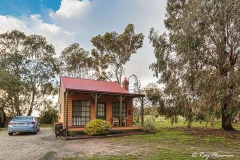
Staying in a cabin at the Mountain View Holiday Lodge was an enjoyable place to chill out. Also, we had opportunities to view wildlife in the gardens, such as kangaroos and birds. We usually like to book accommodation within walking distance of restaurants. Although, on this occasion, we were out of town but still only about a five-minute drive away. And just a five-minute drive to Barney’s Bar & Bistro in Pomonal.
Grand Canyon Loop Scenic Walk
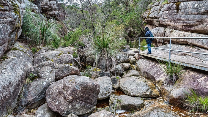
Grampians Grand Canyon Loop Trail
A narrow part of the Grampians Grand Canyon Loop trail, a boardwalk helps pass weathered boulders in the creek.
[foogallery id=”17696″]
The Grand Canyon Loop Walk is a short 900-metre moderate walk starting and finishing at the Wonderland carpark in the Grampians. When we set off for the walk, it was grey and cloudy but improved as we walked. We crossed over Stony Creek from the carpark, then turned left to pick up the clockwise trail. The outward trail follows a creek. Difficult sections have handrails, boardwalks, and at the end, some metal steps to ease the climb out of the canyon. There is a left turn at the top of the canyon for a 4.2 km strenuous walk to the Pinnacle. However, we returned to the carpark via the Sandstone Terraces.
There were several spring wildflowers on the sandstone terraces.
Grampians Lookouts – Boroka, The Balconies and Reed
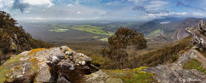
Grampians Boroka Lookout
Grampians Boroka Lookout panorama view encompassing Lake Lonsdale, Lake Fyans, Lake Bellfield, and Halls Gap.
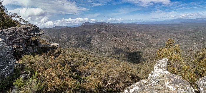
The Balconies Lookout
South-Easterly View from The Balconies in the Grampians Mountains.
[foogallery id=”17687″]
There are several lookouts only a short drive from Halls Gap village. First, we drove to Boroka Lookout early in the morning, but mist and low cloud obscured our view. So, we backtracked to walk the Grand Canyon Loop returning later when the low cloud had cleared.
Boroka Lookout is only a short walk from the car park and provides a panoramic view across the eastern plains. Landmarks from left to right included Lonsdale and Fyans lakes, Halls Gap Valley and Lake Belfield.
Further west was Reed Lockout, providing southerly views across the valley towards Victoria Range.
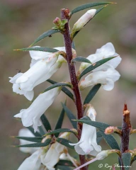
From Reed Lookout, there is a one-kilometre path to The Balconies, which had southerly panoramas. There is an area of loose stone along the trail, a magnet for rock stackers. Also, there were many spring-flowering wild plants along the track; the gallery features Victoria State floral emblem, the Common (pink) Heath.
MacKenzie Falls and Silverband Falls
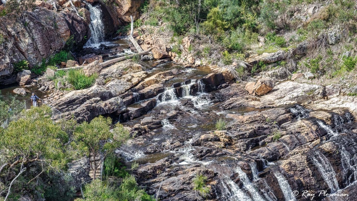
MacKenzie Falls from Bluff Lookout
MacKenzie Falls from Bluff Lookout in the Grampians National Park.
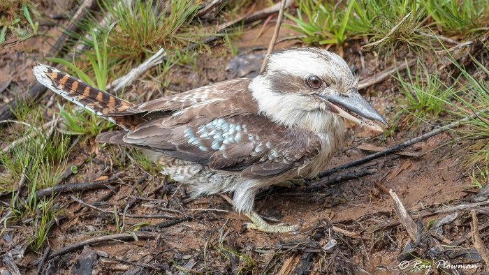
Laughing Kookaburra at MacKenzie Falls
Laughing Kookaburra (Dacelo novaeguineae) foraging on the ground at MacKenzie Falls in Australia’s Grampian Mountains.
[foogallery id=”17705″]
MacKenzie Falls
The falls in Victoria’s Grampians is an easy 1.9 km return walk to Bluff Lookout. Also, it has a circular section for the last one-third of its length.
There is a vista of the falls at the Bluff Lookout, but it is not a particularly good vantage point. So, the highlight of this walk was not the lacklustre falls but photographing a Laughing Kookaburra on the fence post. Further, it started preening itself and then swooped down to the ground when it saw some prey. Another highlight was the rare white form of a Wax-lip Orchid (Glossodia major) and the more common purple form.
Silverband Falls
These falls are at the end of an easy-going 1.4-kilometre return track alongside Dairy Creek. The walk starts at the Silverband Falls carpark on Silverband Road.
The track was not particularly scenic as there was much tree debris beside the trail and in the creek. The area was also open, and the trees were black and charred, resulting from wildfires in 2006. Moreover, the area flooded in 2010. It will take time for the region to recover.
Brambuk, the National Park and Cultural Centre
We stopped one lunchtime at Brambuk, the National Park and Cultural Centre, located south of the town. It celebrates the cultures of the Jadawadjali and Djab Wurrung Peoples. Also, it has a café, indoor cultural activities, and a park visitor information desk.
While walking in Brambuk, I photographed the white form of common heath. There are many colour forms, including red. The pink form of common heath is the Victoria State Floral Emblem.
One Tree Hill Lookout
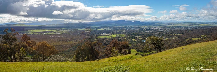
One Tree Hill (Pioneer) Lookout
Panorama from One Tree Hill (Pioneer) Lookout towards Mount Langi Ghiran, Mount Cole, and Ararat.
[foogallery id=”17710″]
The drive from Halls Gap to Phillip Island is around 400 kilometres. So, we had limited little time for en-route stops. Ararat Hills Regional Park’s One Tree (Pioneer) Lookout was a worthwhile detour. There are southwest views towards Grampians and easterly views towards Ararat, Mount Langi Ghiran and Mount Cole. Also, we stopped in Ballarat for a self-guided historic heritage walk. Since we planned to end our tour in Melbourne, we did not stop, just pressed on to Cowes on Phillip Island.
Continue the 2013 Tour of Victoria
We drove from the Grampians to Cowes on Phillip Island. ‘Next’ to continue to the Phillip Island, Gippsland, Lakes Entrance, and Wilsons Prom webpage.
Or ‘VIC’ to go to the Nature and Wildlife in Victoria, Australia webpage.
Bibliography – Online Resources
1. Grampian Mountains National Park. [Online] Available from https://www.parks.vic.gov.au/ [Accessed 23-Janl-22].
2. Halls Gap Village. Available from Available https://www.visitgrampians.com.au/ [Accessed 23-Janl-22].